


 |
 |
 |
|
Day One Hazard Outlook
|
| |||||||
|
| |||||||

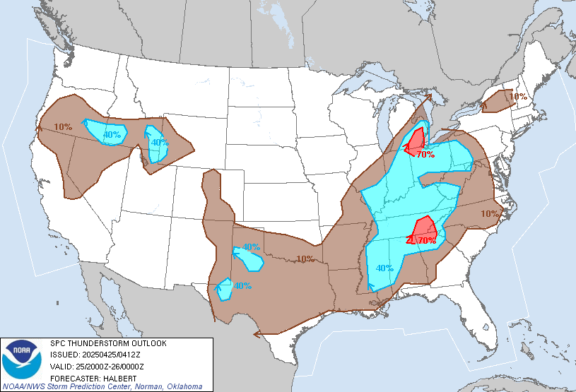
Day 1 Convective Outlook - NWS SPC

|
|
|
||
 |
 |
||
|
|
|
||
|
|
|
||
 |
 |
||
|
|
|
||
 |
 |
||

| |||
|
SPC Convective Outlooks (Details)
Storm Prediction Center Products NWS GSP Text Products:
|


Upstate South Carolina Storm Forecast
Upstate Weather Meteogram
Updated: 31-Jan-2022 10:00 pm
 |
 |
 |
|
 |
 |
|
 |
|
|
 |
|
|
|
|
|
|
 |
|
 |
|
|
|
|
|
|
|
 3.9 |
4.1 |
 4.7 |
 3.7 |
2.3 |
2.4 |
3.3 |
 2.6 |
2.5 |
2.5 |
 2.3 |
 3.4 |
6.4 |
 7.3 |
8.4 |
 8.4 |
 5.5 |
5.3 |
6.6 |
6.2 |
5.1 |
7.5 |
7.7 |
6.3 |
3.3 |
2.5 |
2.3 |
Click to show/hide:
Storm Forecast
Click to show/hide:
Info: Storm Index is our own index for storm possiblity, using Lifted Index, Severe Index, Convection Index and dewpoint.
1-3 indicates possibilty for storms and above 3 storms are likely.
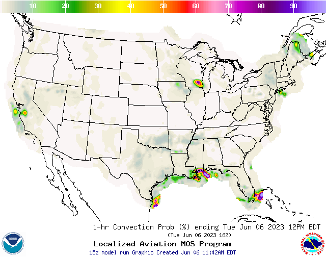
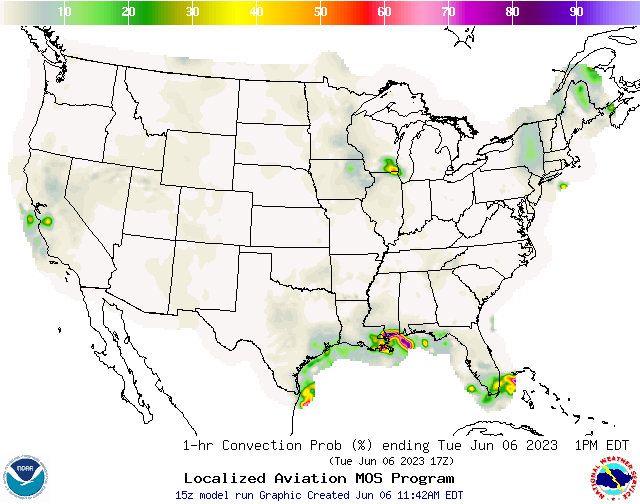
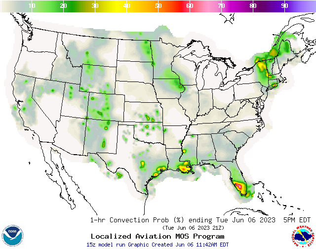
NWS Convection Probabilities
|
|
|
 |
 |
|
|
|
|
|
|
 |
 |
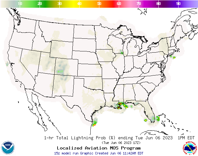
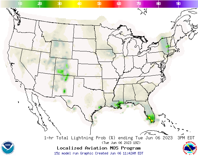
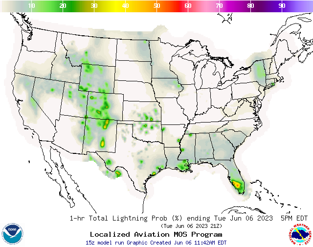
NWS Lightning Probabilities
|
|
|
 |
 |
|
|
|
|
|
|
 |
 |
NWS Greenville/Spartanburg/Greer Weather Forecast Office
NWS Hazardous Weather Outlook
County Warning Area [CWA]: GSP
Regional NWS Weather Office: Greenville/Spartanburg/Greer, SC
County Warning Area [CWA]: GSP
Regional NWS Weather Office: Greenville/Spartanburg/Greer, SC
000
FLUS42 KGSP 200201
HWOGSP

Hazardous Weather Outlook
National Weather Service Greenville-Spartanburg SC
1001 PM EDT Fri Apr 19 2024

GAZ010-017-018-026-028-029-NCZ033-035>037-048>053-056>059-062>065-
068>072-082-501>510-SCZ008>014-019-101>109-210215-
Rabun-Habersham-Stephens-Franklin-Hart-Elbert-Avery-Alexander-
Iredell-Davie-Madison-Yancey-Mitchell-Swain-Haywood-Buncombe-Catawba-
Rowan-Graham-Northern Jackson-Macon-Southern Jackson-Transylvania-
Henderson-Cleveland-Lincoln-Gaston-Mecklenburg-Cabarrus-Union NC-
Caldwell Mountains-Greater Caldwell-Burke Mountains-Greater Burke-
McDowell Mountains-Eastern McDowell-Rutherford Mountains-
Greater Rutherford-Polk Mountains-Eastern Polk-Cherokee-York-
Anderson-Abbeville-Laurens-Union SC-Chester-Greenwood-
Oconee Mountains-Pickens Mountains-Greenville Mountains-
Greater Oconee-Greater Pickens-Central Greenville-
Southern Greenville-Northern Spartanburg-Southern Spartanburg-
1001 PM EDT Fri Apr 19 2024

This Hazardous Weather Outlook is for northeast Georgia, piedmont
North Carolina, western North Carolina and upstate South Carolina.

.DAY ONE...Tonight.

A few lingering showers and thunderstorms will continue across the
area through late evening. Storms will have the potential to produce
gusty winds, small hail, torrential downpours, and cloud-to-ground
lightning.

.DAYS TWO THROUGH SEVEN...Saturday through Thursday.

No hazardous weather is expected at this time.

.SPOTTER INFORMATION STATEMENT...

None.

$$
| Hazardous Wx Outlook from: NOAA-NWS |
| Script developed by: El Dorado Weather & modified by: SE Lincoln Weather |