


 |
 |
 |
|
Day One Hazard Outlook
|
| |||||||
|
| |||||||

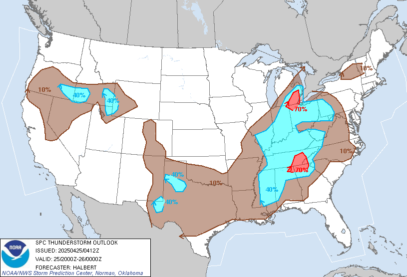
Day 1 Convective Outlook - NWS SPC

|
|
|
||
 |
 |
||
|
|
|
||
|
|
|
||
 |
 |
||
|
|
|
||
 |
 |
||

| |||
|
SPC Convective Outlooks (Details)
Storm Prediction Center Products NWS GSP Text Products:
|


Upstate South Carolina Storm Forecast
Upstate Weather Meteogram
Updated: 31-Jan-2022 10:00 pm
 |
 |
 |
|
 |
 |
|
 |
|
|
 |
|
|
|
|
|
|
 |
|
 |
|
|
|
|
|
|
|
 3.9 |
4.1 |
 4.7 |
 3.7 |
2.3 |
2.4 |
3.3 |
 2.6 |
2.5 |
2.5 |
 2.3 |
 3.4 |
6.4 |
 7.3 |
8.4 |
 8.4 |
 5.5 |
5.3 |
6.6 |
6.2 |
5.1 |
7.5 |
7.7 |
6.3 |
3.3 |
2.5 |
2.3 |
Click to show/hide:
Storm Forecast
Click to show/hide:
Info: Storm Index is our own index for storm possiblity, using Lifted Index, Severe Index, Convection Index and dewpoint.
1-3 indicates possibilty for storms and above 3 storms are likely.
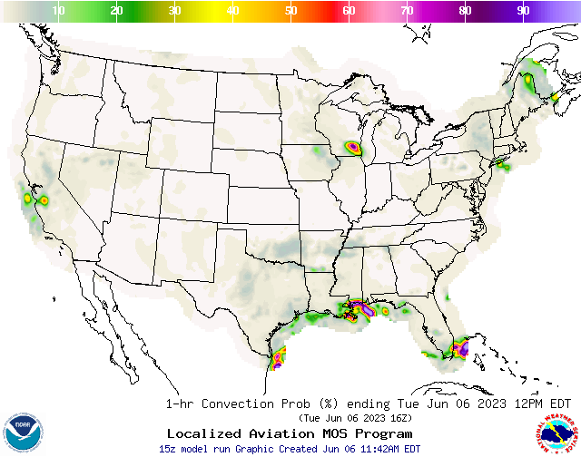
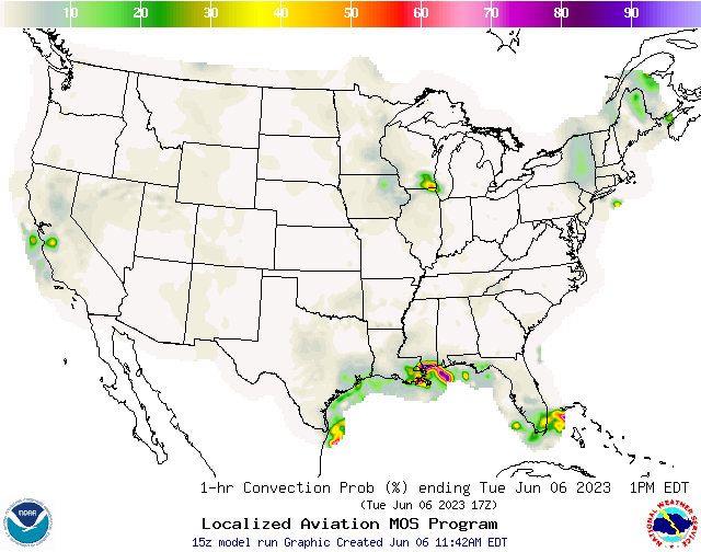
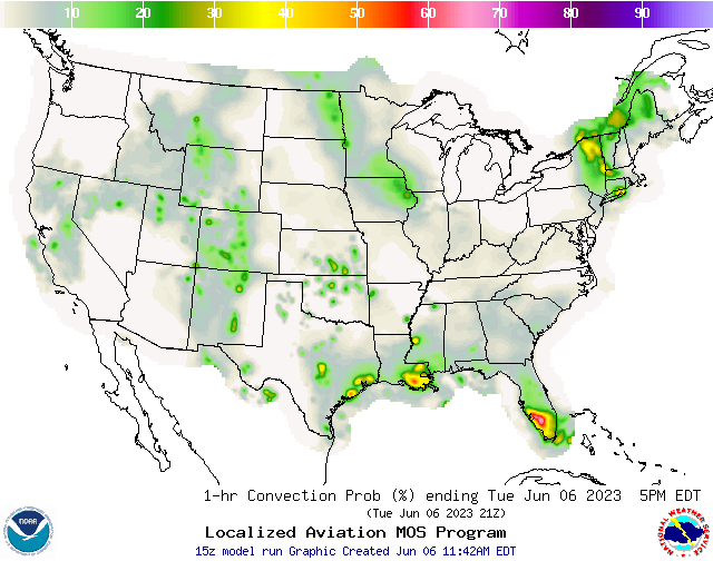
NWS Convection Probabilities
|
|
|
 |
 |
|
|
|
|
|
|
 |
 |
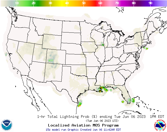
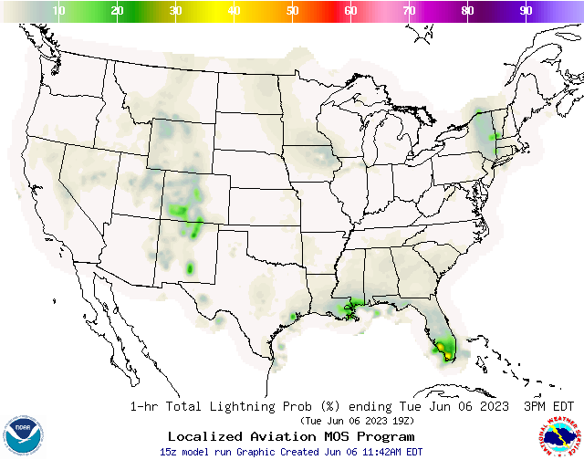
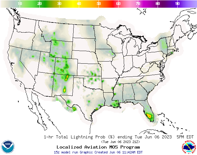
NWS Lightning Probabilities
|
|
|
 |
 |
|
|
|
|
|
|
 |
 |
NWS Greenville/Spartanburg/Greer Weather Forecast Office
NWS Hazardous Weather Outlook
County Warning Area [CWA]: GSP
Regional NWS Weather Office: Greenville/Spartanburg/Greer, SC
County Warning Area [CWA]: GSP
Regional NWS Weather Office: Greenville/Spartanburg/Greer, SC
000
FLUS42 KGSP 221821
HWOGSP

Hazardous Weather Outlook
National Weather Service Greenville-Spartanburg SC
221 PM EDT Mon Apr 22 2024

GAZ010-017-018-026-028-029-NCZ033-049-050-501-503-505-SCZ008>014-019-
101>109-231830-
Rabun-Habersham-Stephens-Franklin-Hart-Elbert-Avery-Yancey-Mitchell-
Caldwell Mountains-Burke Mountains-McDowell Mountains-Cherokee-York-
Anderson-Abbeville-Laurens-Union SC-Chester-Greenwood-
Oconee Mountains-Pickens Mountains-Greenville Mountains-
Greater Oconee-Greater Pickens-Central Greenville-
Southern Greenville-Northern Spartanburg-Southern Spartanburg-
221 PM EDT Mon Apr 22 2024

This Hazardous Weather Outlook is for northeast Georgia, western
North Carolina and upstate South Carolina.

.DAY ONE...This afternoon and tonight.

No hazardous weather is expected at this time.

.DAYS TWO THROUGH SEVEN...Tuesday through Sunday.

No hazardous weather is expected at this time.

.SPOTTER INFORMATION STATEMENT...

None.

$$

NCZ048-051>053-058-059-062>065-502-504-506>510-231830-
Madison-Swain-Haywood-Buncombe-Graham-Northern Jackson-Macon-
Southern Jackson-Transylvania-Henderson-Greater Caldwell-
Greater Burke-Eastern McDowell-Rutherford Mountains-
Greater Rutherford-Polk Mountains-Eastern Polk-
221 PM EDT Mon Apr 22 2024

...FROST ADVISORY IN EFFECT FROM 2 AM TO 9 AM EDT TUESDAY...

This Hazardous Weather Outlook is for western North Carolina.

.DAY ONE...This afternoon and tonight.

Please listen to NOAA Weather Radio or go to weather.gov on the
Internet for more information about the following hazards.

   Frost Advisory.

.DAYS TWO THROUGH SEVEN...Tuesday through Sunday.

Please listen to NOAA Weather Radio or go to weather.gov on the
Internet for more information about the following hazards.

   Frost Advisory.

.SPOTTER INFORMATION STATEMENT...

None.

$$

NCZ035>037-056-057-068>072-082-231830-
Alexander-Iredell-Davie-Catawba-Rowan-Cleveland-Lincoln-Gaston-
Mecklenburg-Cabarrus-Union NC-
221 PM EDT Mon Apr 22 2024

This Hazardous Weather Outlook is for piedmont North Carolina.

.DAY ONE...This afternoon and tonight.

Patchy frost is possible tonight. Sensitive outdoor plants may be
adversely affected if left outdoors or uncovered.

.DAYS TWO THROUGH SEVEN...Tuesday through Sunday.

No hazardous weather is expected at this time.

.SPOTTER INFORMATION STATEMENT...

None.

$$

Krentz
| Hazardous Wx Outlook from: NOAA-NWS |
| Script developed by: El Dorado Weather & modified by: SE Lincoln Weather |