


 |
 |
 |
|
Day One Hazard Outlook
|
| |||||||
|
| |||||||

Day 1 Convective Outlook - NWS SPC

|
|
|
||
 |
 |
||
|
|
|
||
|
|
|
||
 |
 |
||
|
|
|
||
 |
 |
||

| |||
|
SPC Convective Outlooks (Details)
Storm Prediction Center Products NWS GSP Text Products:
|


Upstate South Carolina Storm Forecast
Upstate Weather Meteogram
Updated: 31-Jan-2022 10:00 pm
 |
 |
 |
|
 |
 |
|
 |
|
|
 |
|
|
|
|
|
|
 |
|
 |
|
|
|
|
|
|
|
 3.9 |
4.1 |
 4.7 |
 3.7 |
2.3 |
2.4 |
3.3 |
 2.6 |
2.5 |
2.5 |
 2.3 |
 3.4 |
6.4 |
 7.3 |
8.4 |
 8.4 |
 5.5 |
5.3 |
6.6 |
6.2 |
5.1 |
7.5 |
7.7 |
6.3 |
3.3 |
2.5 |
2.3 |
Click to show/hide:
Storm Forecast
Click to show/hide:
Info: Storm Index is our own index for storm possiblity, using Lifted Index, Severe Index, Convection Index and dewpoint.
1-3 indicates possibilty for storms and above 3 storms are likely.
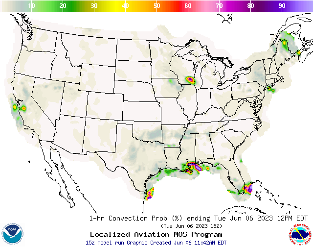
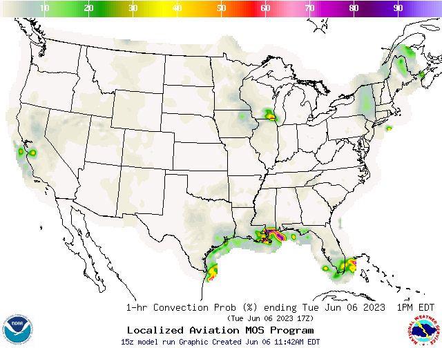
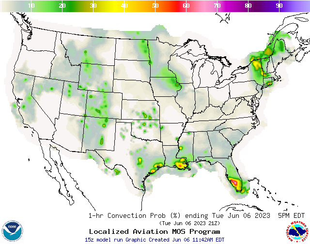
NWS Convection Probabilities
|
|
|
 |
 |
|
|
|
|
|
|
 |
 |
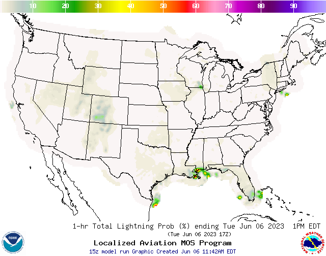
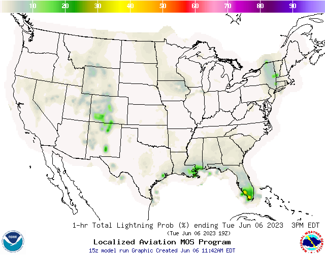
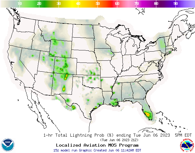
NWS Lightning Probabilities
|
|
|
 |
 |
|
|
|
|
|
|
 |
 |
NWS Greenville/Spartanburg/Greer Weather Forecast Office
NWS Hazardous Weather Outlook
County Warning Area [CWA]: GSP
Regional NWS Weather Office: Greenville/Spartanburg/Greer, SC
County Warning Area [CWA]: GSP
Regional NWS Weather Office: Greenville/Spartanburg/Greer, SC
000
FLUS42 KGSP 160806
HWOGSP

Hazardous Weather Outlook
National Weather Service Greenville-Spartanburg SC
406 AM EDT Tue Apr 16 2024

NCZ033-048>050-053-501-503-505-170815-
Avery-Madison-Yancey-Mitchell-Buncombe-Caldwell Mountains-
Burke Mountains-McDowell Mountains-
406 AM EDT Tue Apr 16 2024

This Hazardous Weather Outlook is for western North Carolina.

.DAY ONE...Today and tonight.

A few isolated to scattered thunderstorms will be possible this
afternoon across portions of the mountains with cloud-to-ground
lightning. Any stronger storms will be capable of producing locally
damaging wind gusts and small hail.

.DAYS TWO THROUGH SEVEN...Wednesday through Monday.

Hazardous weather is not expected at this time.

.SPOTTER INFORMATION STATEMENT...

None.

$$

GAZ010-017-018-026-028-029-NCZ035>037-051-052-056>059-062>065-
068>072-082-502-504-506>510-SCZ008>014-019-101>109-170815-
Rabun-Habersham-Stephens-Franklin-Hart-Elbert-Alexander-Iredell-
Davie-Swain-Haywood-Catawba-Rowan-Graham-Northern Jackson-Macon-
Southern Jackson-Transylvania-Henderson-Cleveland-Lincoln-Gaston-
Mecklenburg-Cabarrus-Union NC-Greater Caldwell-Greater Burke-
Eastern McDowell-Rutherford Mountains-Greater Rutherford-
Polk Mountains-Eastern Polk-Cherokee-York-Anderson-Abbeville-Laurens-
Union SC-Chester-Greenwood-Oconee Mountains-Pickens Mountains-
Greenville Mountains-Greater Oconee-Greater Pickens-
Central Greenville-Southern Greenville-Northern Spartanburg-
Southern Spartanburg-
406 AM EDT Tue Apr 16 2024

This Hazardous Weather Outlook is for northeast Georgia, piedmont
North Carolina, western North Carolina and upstate South Carolina.

.DAY ONE...Today and tonight.

No hazardous weather is expected at this time.

.DAYS TWO THROUGH SEVEN...Wednesday through Monday.

No hazardous weather is expected at this time.

.SPOTTER INFORMATION STATEMENT...

None.

$$
| Hazardous Wx Outlook from: NOAA-NWS |
| Script developed by: El Dorado Weather & modified by: SE Lincoln Weather |